
AlphaAir 15
Pushing the Boundaries of UAV Sensing and Mapping
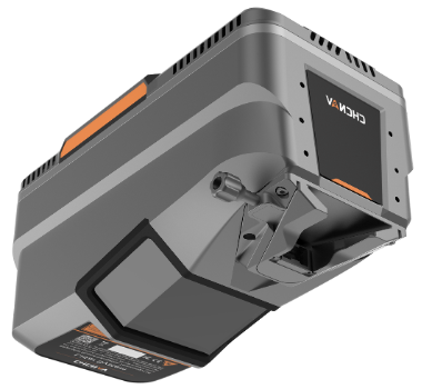
Built on cutting-edge LiDAR technology, the AA15 combines high-end CHCNav laser scanner, high-end multi-constellation GNSS/inertial sensors, and an add-on high-resolution RGB camera
- Long-range LiDAR scanning capability of up to 1800 m
- Highest data quality and point density, up to 2 million measurements per second, scan speed up to 600 lines per second, and field of view of 75°
- Supports several external camera accessories, including CHCNAV’s 45 or 61 MP full-frame calibrated cameras and a 130 MP oblique camera
- Flexible and easy installation on diverse platforms, including helicopters, small aircrafts, and various drones, including CHCNav X500
- Seamless data processing, feature extraction, and compatibility with other industry-standard tools
- Ideal for large-scale corridor mapping operations such as power lines, highways, railroads and pipeline inspections, and well suited for open-pit mining, urban mapping and forestry applications
Key Specifications
Laser Scanner
| range precision | 5 mm (1σ @ 150 m) |
| range accuracy | 15 mm (1σ @ 150 m) |
| max. range | 900 m (reflectivity >20%) |
| Laser beam divergence | 0.032° @1/e2 (5.6 mm @ 100 m) |
| field of view | 75° |
| scan rate | up to 2 MHz (selectable) |
| max. effective measurement rate | up to 2,000,000 pts/sec |
| number of returns | up to 16 (depending on selected scan rate) |
| scan speed | 50-600 lines/sec (selectable) |
| point density | 720 pts/sqm @ 140 m AGL, 10 m/s (19.44 kn) speed |
| angular resolution | 0.001° |
Imaging System
| camera type | CHCNAV 45 or 61 MP full-frame calibrated cameras and a 130 MP half-fame oblique camera (optional for third-party oblique or orthho cameras) |
| Airborne default camera | CHCNAV C5 45 MP full-frame |
| resolution | 45 MP, 8184 x 5460 (36 mm x 24 mm) |
Positioning and Orientation
| GNSS | multi-constellation, triple-frequency GNSS, L-Band |
| IMU | high-precision with up to 600 Hz |
| POS accuracy (no GNSS outage) | Horizontal: 1 cm (RMS) Vertical: 2 cm (RMS) Pitch/Roll 0.005 degrees (RMS) Heading 0.01 degrees (RMS) |
General System Performance
| Absolute accuracy | 2-5 cm (Horizontal and Vertical) (without control points, @ 150 m AGL with 8 m/s speed) |
| Total system weight | 2.5 kg (without camera) |
| Operating temperature | -20°C ~ +50°C |