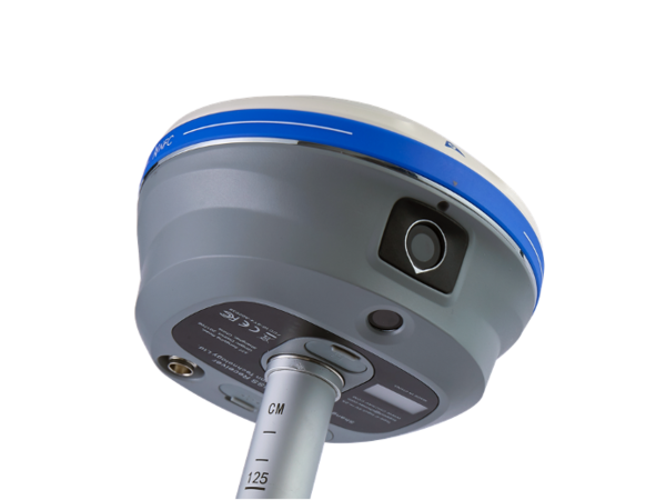
The i93 GNSS receiver is an extremely versatile RTK that integrates the latest GNSS, IMU, and premium dual-camera technologies for a more compelling user experience. Its 3D visual stakeout feature provides unparalleled ease of use and comfort, boosting efficiency for any construction site layout project. Visual survey with video-photogrammetry technology enables accurate point measurements and access to previously hard-to-reach, signal obstructed, and hazardous points. The i93 GNSS can be used to complement aerial surveys generated from oblique imagery since its data is compatible with the most popular 3D modeling software. The i93 GNSS receiver is powered by the innovative CHCNAV iStar GNSS RTK algorithm, multi-band GNSS channels, and hybrid engine for reliable, high accuracy positioning in even the most challenging site conditions. The Auto-IMU of i93 features automatic initialization, eliminating the hassle of manual initialization and simplifying surveying operations in the field. The i93 is the ideal solution for completing tasks faster, more accurately, and more efficiently.
Main Features
- 1408 channels, and tracks all GNSS constellations and frequencies
- built-in hybrid engine and proprietary narrowband interference mitigation technique
- high-end auto-IMU, which enables high accuracy throughout the project, eliminates the hassle of manual initialization, and simplifies surveying operations in the field
- accurate visual positioning through innovative video photogrammetry, which simplifies point measurements and facilitates surveying in hard-to-reach, signal-obstructed, and hazardous locations
- immersive 3D visual stakeout experience, boosting efficiency and productivity
- accurate and complete 3D models of structures through fusion of drone-based oblique imagery and i93-generated images
- featuring automatic pole-tilt compensation in real time, accurate visual positioning and immersive 3D visual stakeout experience